Older TAFs
TAF Impact Board
5-min ASOS Data
Winds Aloft
Hourly Forecast
General Public Forecast
Older TAFs
TAF Impact Board
5-min ASOS Data
Winds Aloft
Hourly Forecast
General Public Forecast
Older TAFs
TAF Impact Board
5-min ASOS Data
Winds Aloft
Hourly Forecast
General Public Forecast
Older TAFs
TAF Impact Board
5-min ASOS Data
Winds Aloft
Hourly Forecast
General Public Forecast
Older TAFs
TAF Impact Board
5-min ASOS Data
Winds Aloft
Hourly Forecast
General Public Forecast
Older TAFs
TAF Impact Board
5-min ASOS Data
Winds Aloft
Hourly Forecast
General Public Forecast
Older TAFs
TAF Impact Board
5-min ASOS Data
Winds Aloft
Hourly Forecast
General Public Forecast
.AVIATION /08Z FRIDAY THROUGH TUESDAY/...
Through 06Z Saturday...VFR conditions expected for the northern
NY and north-central VT TAF sites for most of the TAF cycle
ending 06Z/SAT. Sct-bkn mid level cloudiness continues for the
terminals this morning with some ridging building in from the
north. Some brief patchy fog may occur near KSLK in the IFR
range and a TEMPO group was used 06Z-10Z/FRI.  The dry weather
will persist most of the afternoon with clouds thickening and
lowering, as frontal boundary begins lifting northward from the
I-90 corridor of NY. Clouds bases lower to the 3.5-7 kft AGL
between 18Z/FRI and 04Z/SAT from south to north with VCSH groups
introduced at KRUT/KMPV initially between 18Z-20Z/FRI and then
expand further north shortly before or just after 00Z/SAT.
Showers may need to be added to several of the TAF sites after
00Z/SAT with an introduction at KMSS at 03Z/SAT.

The winds will vary in direction and be 4 KT or less this
morning. They will be from the north/northeast to the
east/southeast at less than 10 KT during the late morning into
the afternoon. The winds will be south/southeast at less than
10 KT after 00Z/SAT.

Outlook...

Friday Night: Mainly VFR, with local MVFR possible. Definite SHRA.
Saturday: Mainly MVFR, with local IFR possible. Definite SHRA.
Saturday Night: Mainly MVFR, with local IFR possible. Chance
SHRA.
Sunday: Mainly MVFR, with areas VFR possible. Chance SHRA.
Sunday Night to Monday Night: VFR. NO SIG WX Tuesday: VFR.
Chance SHRA.
Click on Radar and Satellite images below for a loop.
|
Radar Loop
|
Current Weather Map
|
|
Visible Satellite Loop
|
Infrared Satellite Loop
|
|
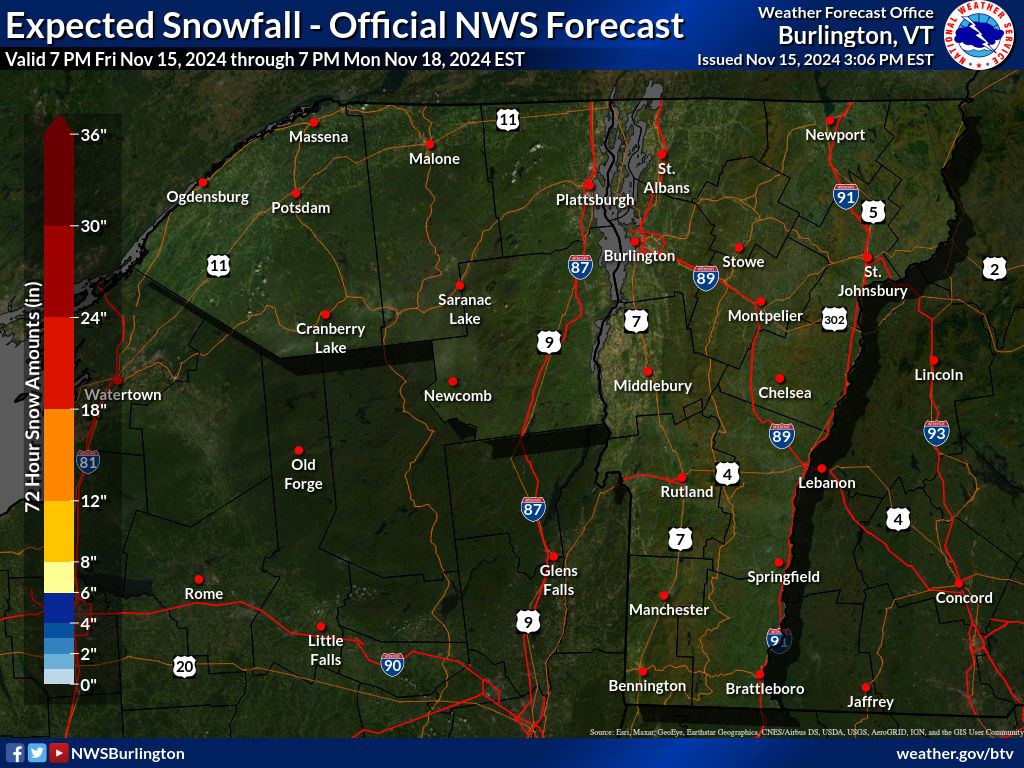
Expected Snowfall
|
Expected Ice Accumulation
|
Click on images below to enlarge.
|
Radar Loop
|
Convective SIGMETs
|
TFM Convective Forecast (TCF)
|
|
SPC Day 1 Convective Outlook
|
SPC Day 2 Convective Outlook
|
SPC Day 3 Convective Outlook
|
|
Current Icing SIGMETs
|
CIP/FIP Icing Guidance
|
|
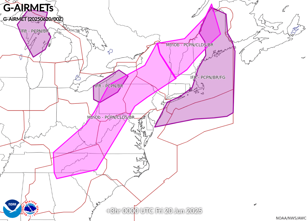
00-03 hr Icing AIRMETs
|
03-06 hr Icing AIRMETs
|
|
06-09 hr Icing AIRMETs
|
09-12 hr Icing AIRMETs
|
|
Current Turb SIGMETs
|
Turbulence Guidance (GTG)
|
|
00-03 hr Turb/LLWS AIRMETs
|
03-06 hr Turb/LLWS AIRMETs
|
|
06-09 hr Turb/LLWS AIRMETs
|
09-12 hr Turb/LLWS AIRMETs
|
|
00-03 hr Visibility AIRMETs
|
03-06 hr Visibility AIRMETs
|
|
06-09 hr Visibility AIRMETs
|
09-12 hr Visibility AIRMETs
|